
The area gives plenty of opportunities to explore the high Ardennes.
The valley of the small river Lienne offers idyllic streams, typical Ardenese villages, a meadow landscape with majestic free standing trees, and cows and horses of all types.
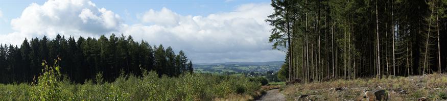
Higher up the hills, you find the woods and moorlands, and beautiful vistas of the valleys. Pay attention to the birds of prey. Apart from the more common buzzards and kestrels, recent years we saw also plenty of red kites with their beautiful agile flight. Every season gives its own accents and charm to the landscape. Due to the average altitude of 400m (1200 ft) summers are wonderfully cool and the winters give more chance of good snow. The air is bright and clean here.
Tarpan hikes.
A local tourist organisation Tarpan has created some 20 marked hikes in the communities of Lierneux and neighbouring Vielsalm.
Three of these pass our hotel, and several others are reached through marked connecting routes.
We have made descriptions of hikes leaving directly from the hostellerie, from a short 1,5 hr walk, or three 3,5 hr to 4,5 hrs walks to a 7-8 hrs daytrip that circles the complete upper Lienne valley. Also we described a few hikes for which you first need a short drive by car to get at the starting point.
We have available at the hotel plastified maps and at the reverse side a detailed description of all these hikes.
There are no restaurants on the way (only in Vielsalm), so take your own food and drinks with you, or ask us the evening before your hike to prepare you a good picnic for €12 p.p.
Hunting
Attention! During the hunting season some hikes are closed.
As soon as they are published, you can find overviews by this link with a map of Lierneux.
If you let me know in advance which hike you would like to do, I will check for you if the hunters will block your plans.
The same time of year, you can expect our cook to include game in his menus.
Geocaching
On the hill (550m) behind Arbrefontaine you find extensive woods with lots of unpaved roads. At about the centre of this wood, at a main crossing of unpaved roads, you find the memorial of a young lumberjack called "croix Barbette". Closeby you can find a geocache.
A marked route (3hrs, blue square in a white rectangle) brings you there from Arbrefontaine, and from croix Barbette on to the small castle Farnière and back to Arbrefontaine.
In hotel you can find a description and map for a 5hrs walk that continues from Farnière all the way to Vielsalm, and past another hill back to Arbrefontaine.
Also mountainbike track 2 from Vielsalm and the bridging track from Arbrefontaine to that track 2 (both well marked), go past croix Barbette.
Hikes with guides.
The tourist office in Vielsalm organises guided excursions at week days for which you can make a reservation.
Amongst others they visit the territory of the beavers in the valley of the river Lienne.
It is also possible to let us organise a guide for you; please ask us some days in advance.
Grand Randonnées (Great Hikes):
GR14 (Parijs - Bouillon - Malmédy - Luik) passes our hostellerie.
GR571 (Vallées des Légendes) passes through the woods right behind Arbrefontaine.
Garmin tracks are made available by previous guests for the hikes 1EN, 3EN and 5EN. Ask for them in advance to be sent by e-mail.
Photogallery Promenades

Overview Map of the hikes that are described below
_Content.jpg)
Of each individual hike you will find a plastified detailed description in English with a map on the reversed side in the hotel at the stairway.
The maps of each hike can be downloaded from the links at each summary below. Upon request I will send you the detailed description by e-mail.
Hikes 1 through 6 start from the hotel.
For hikes 7a, 7b, 8a, 8b, 9a, 9b and 10 you need a short drive by car to get at the starting point.
On the way you won't find any shops or cafés (the only exception is in Vielsalm, hike 3EN), so carry your own food and drinks with you, or ask our staff
the evening before your hike, to prepare you a fine carry away lunch (€12 p.p.).
1EN Lienne Valley Walk (appr. 3.5 hours). Map of the Lienne Valley Walk starting from the hotel.
Or download the GPX track:
1 Dalwandeling_GPS.gpx
If you intend to make only one good hike during your stay at hour hotel, we advise you to make this one, since it is beautiful and full of variation. You go up through the forest to the highest point behind Arbrefontaine (550m); then you get a descent with beautiful views through open fields, villages and along small streams and desolated foot paths, until you cross the Lienne at 300m altitude. There we give you some tips to search for beaver dams. After an evitable 200m over the road you dive into a nature reserve with horses and cattle, and then you climb up through the open fields with lots of opportunities to spot prey birds.
2EN Short Walk of appr. 1.5 hours. Map of the Short Walk starting from the hotel.
A short hike through meadows and forest, with nice views.
You get past the church with characteristic gravestones, a
WW2 memorial of Arbrefontaine and the 17th century cloister (Calvaire) of Arbrefontaine.
3EN Walk through the forest to Vielsalm (appr. 5 hours). Map of the Walk through the forest to Vielsalm starting from and returning to the hotel
Or download the GPX track:
3 Boswandeling_Vielsalm_GPS.gpx
For this hike you should count 5 hours, exclusive of any catering stop in Vielsalm.
The forests of the Ardennes are usually on top of the hills. The bedrock is not far below the surface, so the soil is not well suited for agriculture. Moreover, the water can sometimes hardly escape from the flat rocky hilltops, that is why it is here, where you find the swampy peat ("Fagnes"). On the slopes, the water runs down along the path of least resistance, which often are the hiking trails. Therefore, good footwear is recommended, even in dry periods. The forests are used for the timber industry and for hunting. The logging gives sometimes surprising vistas and forests of all ages. Therefore this is a varied forest walk. In the hunting season one should check before leaving, if the planned route will run through a cordoned area. The hostelry has this information. At the same time, as hunting brings wildlife in motion, one also has more chance to spot wildlife. The town Vielsalm houses several restaurants for a good stop.
4EN Hike to the stone quarry (over 4 hours). Map of the Hike to the stone quarry starting from the hotel.
Or download the GPX track:
4 Steengroeve_Carriere_GPS.gpx
Book your lunch the night before at the hotel, because there is no shop or restaurant on the way.
The quarry that this hike will go by, is where the beautiful pruple and green/grey stones come from that are used for the typical houses of Arbrefontaine.
This route takes you first past the
war memorial of Arbrefontaine, up the wooded hill, and then along hilltops in open countryside in over 2 hours to Verleumont. Then you walk through a small valley with badger setts in about 2 hours back to La Maison de Maitre. Before Verleumont you can also shorten the route by approximately 1 hour.
5EN Extended Lienne Valley Walk (appr. 7 hours). Map of the Extended Lienne Valley walk starting from the hotel.
Or download the GPX track:
5 dalwandeling 7h.gpx
Only after almost 6 hours, in Lierneux, you will find one small café, so take you own food and drinks or ask our staff the evening before your hike for a fine cary-away lunch.
This hike is identical to hike 1EN until the bridge over the river Lienne. After that this hikes continues up the other side of the valley, past a viewing point from where you can even spot our hotel. From there you have a nice walk through steep forest until you arrive at Lierneux where we guide you through the property of the pschychiatric institution. After Lierneux you return to the hotel through open terrain with nice vistas an opportunities to spot prey birds.
6EN Walk through the forest to Réharmont and the Lienne vallei (appr. 4 hours).
Map of the Walk through te forest to Réharmont and the Lienne valley, starting from the hotel.
Or download the GPX track: 6 Boswandeling_Reharmont_GPS.gpx
There are no cafés or shops along this walk, so take your own food and drinks with you, or aks our staff the night before to prepare you a packed lunch. After 2.5hrs there is a covered picknick spot with a nice view over the Lienne valley. The walk takes you from La Maison de Maitre through the woods over the hill to Reharmont. Then you return through the farm of Noirefontaine and along the manor of Amcomont, with views over the hilly open Lienne Valley, through Odrimont back to Arbrefontaine.
7EN The hikes through Baneux. Map of the hikes through Baneux
The Extended Lienne Valley walk (walk number 5EN) brings you to Baneux all the way from the hotel. But if you do not fancy walking for 7-8 hours, then it is definitely worth to take the car to explore that side of the Lienne valley. There is no catering on the way, so carry your own lunch or ask our staff the evening before.
7a The hike indicated by the signs with a yellow rectangle takes appr. 3 hrs.
You can start this hike indicated by the signs with a yellow rectangle in Baneux, but most people prefer to have the biggest climb in the beginning. In that case, you drive by car to Lierneux. You then start off with a steep climb from the bottom of the valley directly to the highest point. There is a covered viewpoint/pick-nick area from where you can see even Hostellerie La Maison de Maître (the white side wall). On the information panel you can read a nice historical description of Arbrefontaine, including that the village was founded as Alba Fontana. On the map of 1744 that hangs in the period dining room in our hotel, the villages name is somewhere halfway: Albfontaine. Almost all the rest of the hike you will have stunning views.
7b The combination of 2 hikes, indicated by the signs with respectively red and blue/whie rectangles, takes approximately 2.5 hours.
For this combination of two routes you drive to Lierneux. There you pick up the route indicated by the red rectangles, which takes you on a path diagonally up across the ski slopes into the forest on the hill. After a while the trail plunges steeply over rocky ground. You there switch to the blue horizontal rectangle signs. These take you right into the forest, first along a picturesque stream and later through a path up and up to Baneux. After the Tarpan information panel, it pays to go up again for 200m along the route with the yellow rectangle, to get to the view point with information panel (see the route description of the yellow rectangle, above). You will have to go back the same way to the Tarpan information panel. Then continue to follow the blue and white route again. After some 10min the path goes down through the forest. You go through an old path that is worn out fors ome meters deep, where you switch back to the route of the red rectangles, to get back to your car.
8EN The hikes starting from Les Villettes. Map of the hikes starting from Les Villettes
The slope of the hill where you find Les Villettes is already a bit more downstream in the Lienne valley, where the valley is cut deeper. Walking down the hills it is therefore a bit darker, but along the top the views are of course all the more spectacular. Three hikes start here: a short one hour hike, and two hikes of approximately 2 hours. The last two can also be connected to make one walk of over 3 hours. The detailed description guides you to Les Villettes, and back by another scenic route.
8a The hike indicated by blue rectangles takes appr. 1.5 hours leads you through the woods to the top of the hill behind Les Villettes, and back again with nice views.
The hike indicated by the green diamond only takes an hour, is short and quite flat too, but it rewards you with nice views. It first goes down a bit into the valley (in the opposite direction than the route of the red rectangles), but it soon climbs up and goes around the hill of Les Villettes, where you are treated on a beautiful view of a pristine stretch of Lienne valley. The return to Les Villettes is with further views along the top.
8b The hike indicated by the signs with a red rectangle takes appr. 2 hours takes you down into the valley, and all the way up through the forest again, where some stamina is required. Where you leave the forest you will be rewarded with a beautiful landscape of meadows and vistas. The last piece runs partly along the paved road to lead you to some nice viewpoints.
9EN The hikes starting from Les Trous de Bra. Map of the hikes starting from Les Trous de Bra
Les Trous the Bra is a tiny village even more downstreams along the Lienne. It still belongs to the Lierneux municipality, but it is the village that is farthest away from our Hostellerie. The walks here are nice and quiet, and perhaps an option if you whish to do a good hike on the last day before you to drive home.
9a The one hours hike indicated by signs with a red diamond leads you up through the village whose houses are scattered around a small and steep little stream. You just go through the woods above the village to a point wit a view up to the E25, and then you go down again through the village by the other side of the little valley. At a house behind a huge tree, it seems that you have to pass through the front garden of these people, to a path that goes down steeply. The man that lives there, once told me that as a child in winter he used to go down that path with the sled to school. That old school is special in itself by the way.
9b The hike of over 4 hours, indicated by the yellow rectangle starts off with a nice walk along the scenic Lienne, dotted with a few houses. Then you turn left to a path that steeply goes up with a view. Then you will be for quite some time in the forest. This forest is part of a vast wooded hill where people hunt in the season. That also means that there is a chance for you to see wildlife. Near the highest point you can find a white hexagonal sign that refers to a small rock that you can climb, if you go along the path behind this sign. You descend along a picturesque stream through the forest for a while before turning to the right between two hills to get to a unbeatable view over the lowest part of the Lienne valley, with in the distant the chateau of Neuville.
10EN A hike starting from Grand-Halleux (3 hours). Map of the hike starting from Grand-Halleux
The association Tarpan has made several hiking trails in the municipality Vielsalm. In the hunting season we have information on what days portions of the forest are closed for hunting. Or you can call the tourist office of Vielsalm (+32 - 80 215 052). The walks from Vielsalm itself have the advantage that it is more touristy, so one can use all the related facilities. But Vielsalm is also a somewhat larger village and busier, with a main route and railway running throught the Salm valley. Therefore we find it more difficult to experience the real peacefull sensation of the Ardennes. However this hike starting from the village of Grand-Halleux (on the winding road from Vielsalm to Trois-Ponts), and indicated by signs with a blue square we do recommend. Leaving Grand-Halleux it will take you through the forest on the high hill Le Monti, before going down again with a nice view, passing the tiny village of Ennal, the cozy tavern regretfully doen't serve any meals anymore.
11EN The hikes starting from Hierlot. Map of the hikes starting from Hierlot
Hierlot is another a typical Ardennes village the Lienne valley, some 5 minutes drive from Arbrefontaine.
11a Short walk through the woods featuring beautiful views and a covered picnic area, but no pub (1,5hrs)
You climb up the hill with amazing views of the valley. Then you will walk along the wooded slopes of the hill. You will leave the woods at the big covered pick-nick area with again superb views over the valley. From there you have a beautiful descent back to Hierlot.
11b A short walk through the Lienne valley, with a pub halfway (2,5hrs)
This hike combines the finest pieces of walks 1EN, 5EN and 7EN. You visit the typical villages of Hierlot and Lansival. Along the shores of the Lienne you can search for beaver dams.You go up the hills for some stretches with superb views over the Lienne valley, before getting to Lierneux. Through the backstreets of this small village, you get to the (one and only) pub in Lierneux where they also serve some snacks. Then you descend through the fields back to Hierlot.
Hiking suggestions for a holiday of multiple days:
1 night :
- day1: 1EN (3.5 hrs)
- day2: 7b (2.5 hrs)
2 nights :
- day1: 4EN4 hrs); or 7b (2.5 hrs) when you do 1EN on day2
- day2: 5EN7 hrs) or 1EN3.5 hrs)
- day3: 3EN5 hrs) or 10EN3 hrs)
3 nights :
- day1: 8a (2 hrs), or 7b (2.5 hrs) when you do 1EN on day3
- day2: 3EN (5 hrs)
- day3: 5EN (7 hrs) or 1EN (3.5 hrs)
- day4: 4EN (4 hrs) or 10EN (3 hrs)
4 nights :
- day1: 8a (2 hrs), or 7b (2.5 hrs) when you do 1EN on day3
- day2: 3EN (5 hrs)
- day3: 5EN (7 hrs) or 1EN (3.5 hrs)
- day4: 4EN (4 hrs) or 6EN (4 hrs)
- day5: 10EN (3 hrs)
5 nights (only possilble in July and August):
- day1: 8a (2 hrs), or 7b (2.5 hrs) when you do 1EN on day3
- day2: 3EN (5 hrs)
- day3: 5EN (7 hrs) or 1EN (3.5 hrs)
- day4: 6EN (4 hrs)
- day5: 4EN (4 hrs)
- day6: 10EN (3 hrs)